青藏高原东南缘岩石圈变形与地震构造:多种地球物理资料联合反演的整体视角

研究亮点
本研究构建了青藏高原东南缘高分辨率岩石圈三维密度结构模型。
本研究表明印度-亚洲板块的汇聚可能导致青藏高原东南缘的岩石圈多阶段变形。
本研究揭示含水流体物质侵入可能是造成青藏高原东南缘岩石圈变形的重要原因。
 微信号:ziranziyuan1
更多资料,添加微信
复制微信号
关键词


青藏高原
岩石圈变形
地震构造
新生代
多种地球物理资料
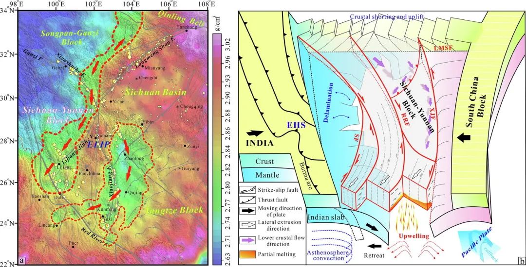
(1)青藏高原东南缘中-下地壳强度较弱,且具有低有效弹性厚度、高热流、低密度/速度和低黏度等特征。这些特征促使下地壳发生韧性流动,为青藏高原地壳物质的侧向挤压提供了重要通道,最终导致青藏高原东南缘岩石圈的多阶段变形。
(2)青藏高原东南缘在新生代经历了3个主要变形阶段:始新世-早渐新世的横向地壳缩短与增厚、晚渐新世-早中新世的沿主要走滑断裂顺时针旋转和侧向挤出、中-晚中新世的下地壳流与区域构造反转。相关驱动因素主要包括岩石圈的复杂结构、物质组成、流变性能、深部热状态以及不同块体间的重力势能等。
(3)岩石圈变形、中-下地壳流体物质侵入和深部熔融物质上涌有利于能量积累和应力集中,这可能为青藏高原东南缘的大地震提供了深部构造驱动。
(4)印度-亚洲板块的汇聚速率、俯冲角度和汇聚过程的时空变化,可能与青藏高原东南缘的多阶段地壳变形和强烈的地震活动密切相关。同时,中-下地壳中的含水流体物质可能在长期重力作用下向外扩散,进一步诱发青藏高原东南缘的岩石圈变形和地震活动。此外,印度板块的俯冲后撤和西太平洋板块的后撤及弧后扩张,也为青藏高原的东向挤出提供了空间。
原文信息
赵斐宇a,b, 李三忠b,c, 索艳慧b,c, 邓居智a, 戴梦雪a, 陈晓a, 胡斌a, 王彦国a, 胡亚平a
a东华理工大学, 战略性矿产成矿理论与深部预测江西省重点实验室, 南昌, 330013
b中国海洋大学, 海底科学与探测技术教育部重点实验室, 青岛, 266100
c崂山实验室, 海洋矿产资源评价与探测技术功能实验室, 青岛, 266237
The southeastern Tibetan Plateau (SETP) plays a pivotal role in accommodating the crustal deformation between the complex Tibet Plateau and the South China Block during the Cenozoic associated with the India-Asia Convergence. In this study, we establish a high-resolution 3-D lithospheric structure model of the SETP through joint inversion of observable multi-geophysical data, to understand its Cenozoic progressive deformation processes, deep seismotectonic environment, as well as regional geodynamic mechanism. We identify two low-density zones within the mid-lower crust that are separated by a pronounced high-density body beneath the inner zone of the Emeishan Large Igneous Province (ELIP). We also image an interconnected channel flow in the lower crust beneath the SETP. To further confirm the relationship between Cenozoic deformation propagation and deep lithospheric architecture, we adopt a holistic perspective from joint inversion of observable multi-geophysical data, coupled with integrated analysis on geometric-kinematic characteristics of major strike-slip fault zones and regional tectonics in the SETP. The results show that the mechanically weak mid-lower crust of the SETP is characterized by low effective elastic thickness (Te), high heat flow, low-density/velocity and low-viscosity, which might accommodate the ductile flow and provide an important channel for the lateral extrusion of crustal materials from the Tibetan Plateau, and ultimately contribute to the episodic lithospheric deformation of the SETP. We trace three main phases of deformation within the SETP during the Cenozoic: the Eocene-early Oligocene latitudinal crustal shortening and thickening, the late Oligocene-early Miocene clockwise rotation and lateral extrusion along major strike-slip faults, and the mid-late Miocene lower crustal flow accompanied with regional kinematic reversal. The lithospheric deformation, the invasion of fluids and the upwelling of deep molten materials are conducive to strain accumulation, which might also explain the occurrence of large earthquakes. Geodynamically, we consider that both the spatio-temporal variance of convergent rates, subduction angle, and processes of the India-Asia Convergence may be associated with episodic crustal deformation and intense seismicity in the SETP. The aqueous fluids in the weak mid-lower crust may have propagated outward due to the long-term gravitational driving forces and contributed to the lithospheric deformation and seismicity of the SETP. Furthermore, the retreat of the subducted Indian slab as well as the rollback and back-arc spreading of the western Pacific Plate also provided favorable conditions for the eastward extrusion of the Tibetan Plateau.
相关研究
主办/《地学前缘(英文)》编辑部
文字/赵斐宇

END
诚邀Geoscience Frontiers广大作者
和读者向期刊公众号供稿!
请联系邮箱geofrontier@cugb.edu.cn。
About Geoscience Frontiers


